New research which maps the entire global population’s travel time to their nearest healthcare facility has revealed major inequalities in access to healthcare depending on whether people have access to motorised transport or not.
Research conducted by the world-leading Malaria Atlas Project, now based at The Kids Research Institute Australia and Curtin University in Perth, Western Australia, and published this week in the journal Nature Medicine found nine out of ten people can reach a hospital or clinic within an hour if they have access to a vehicle or public transport.
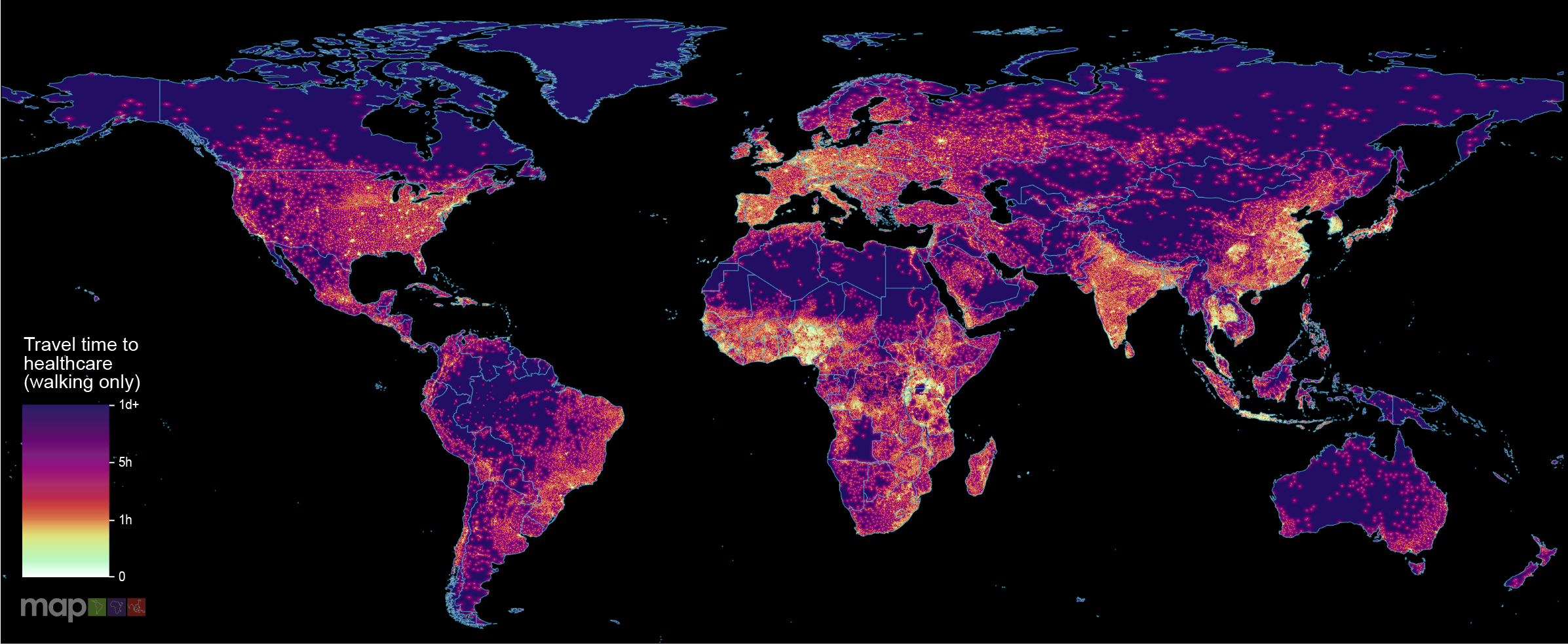
But for people reliant on walking – predominantly in poorer countries – it’s a different story, with 3.16 billion people across the world unable to reach a healthcare facility within an hour if only able to get there on foot.
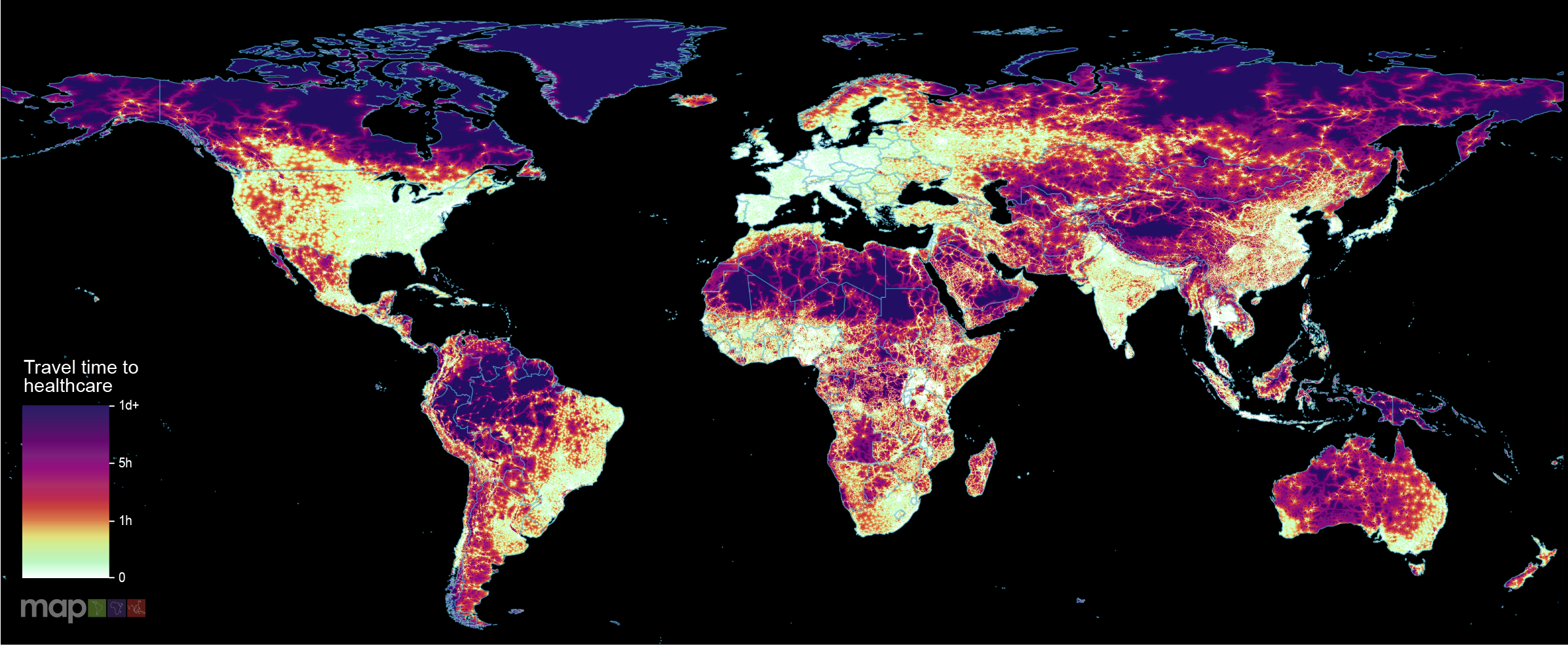
Researchers led by Associate Professor Daniel Weiss crunched massive datasets from sources including Google Maps and OpenStreetMap to produce the first global scale, high resolution travel time maps to visualise how easy it is for people anywhere in the world to reach hospitals and clinics when they need health care.
The lighter areas of the colour-coded maps – each pixel of which corresponds to one square kilometre – reveal where access to a healthcare facility is fastest (an hour or less). The darker the area pictured, the longer it takes for people to reach their nearest facility, with areas shaded black corresponding to more than a day’s travel time to healthcare.
Associate Professor Weiss said access to health care was a requirement for human wellbeing that depended, in part, on the allocation of healthcare resources amongst populations.
“It’s important to know how long it typically takes people to get to their nearest healthcare facilities, because this influences whether individuals seek care when it’s needed,” Associate Professor Weiss said.
“Understanding travel time can also help identify communities which would most benefit from additional healthcare resources – including outreach programs, community healthcare workers, subsidised transportation, telehealth, additional trained personnel for short-staffed facilities, and future facilities placed in optimal locations.
“This is particularly important in the child health context, because young children have the greatest risk of death from communicable diseases globally, and longer travel times lower the likelihood parents will seek care for their ill children.”
The research found more than 91 per cent of people with access to a vehicle or public transport (predominantly people in higher income countries) live within one hour of a healthcare facility, compared to 56.7 per cent of people confined to travelling on foot.
“We found that just 8.9 per cent of the global population (646 million people) cannot reach healthcare within one hour if they have access to motorised transport, and that 43.3 per cent (3.16 billion people) cannot reach a healthcare facility by foot within one hour,” Associate Professor Weiss said.
“Predictably, the results reflected where different places in the world sit on the wealth spectrum. Often those with the worst access to healthcare are shown to be in the most isolated areas – highlighting the additional vulnerability faced by poorer individuals in the remotest parts of the world.”
Associate Professor Weiss said it was the first time this kind of map had been possible.
“A decade ago we couldn’t have done this because the data just didn’t exist,” he said. “This is a great example of big data enabling us to understand and visualise important health issues in ways we couldn’t demonstrate before.
“By merging and analysing major data collection efforts already under way, including by OpenStreetMap and Google Maps, we’ve been able to compile the most complete collection to date of healthcare facility locations worldwide.
“We still can’t be sure that all facilities are accounted for, since we’re limited by the data available, however the information we have managed to collect has enabled us to calculate travel time to healthcare facilities in unprecedented detail.”
To ensure the most up-to-date information, only data sets published in 2019 were included. The team has also made the tool kit they used to create the maps available on an open source basis, enabling others to rapidly create their own maps detailing information relevant to them.
“This isn’t just a set of maps of access to health care, this is the ability for people to make their own travel time maps to any points of interest,” Associate Professor Weiss said. “So if the minister of health of a particular country has better facility data than we had, we give them the tool kit to be able to make their own version within hours.”
He said the maps provide a critical dataset for identifying where gaps in accessibility remain.
“We hope this work will help to ensure more efficient distribution of limited healthcare and transportation resources to underserved populations, both now and in the future,” he said.
The full paper, Global maps of travel time to healthcare facilities, can be read here.
- Associate Professor Weiss is a member of Professor Peter Gething’s Geospatial Health and Development/Malaria Atlas Project team, based at The Kids Research Institute Australia and Curtin University.
- The global accessibility mapping project is the result of a multi-year collaboration between the Malaria Atlas Project (The Kids Research Institute Australia, Curtin University and the University of Oxford), Google, and the University of Twente (Netherlands).
First published Friday 2 October 2020.
View all news articles